Lukla Airport Reviews

Lukla Airport Reviews
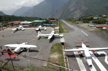
Lukla Airport also known as Tenzing-Hillary Airport (IATA: LUA, ICAO: VNLK) , is a small airport in the town of Lukla, in Khumbu, Solukhumbu district, Sagarmatha zone, eastern Nepal. A program titled Most Extreme Airports, broadcast on The History Channel in 2010, rated the airport as the most dangerous airport in the world.
The Lukla airport’s paved asphalt runway is only accessible to helicopters and small, fixed-wing, short-takeoff-and-landing aircraft such as the De Havilland Canada DHC-6 Twin Otter, Dornier Do 228, and Pilatus PC-6 Turbo Porter. The runway is 460 by 20 m (1,510 by 66 ft) with a 12% gradient. The elevation of the airport is 2,800 m (9,200 ft). In January 2008 the airport was renamed in honor of Sir Edmund Hillary and Sherpa Tenzing Norgay, the first people to reach the summit of Mount Everest and also to mark their efforts in the construction of this airport.
Lukla airport is popular because Lukla is the place where most people start the climb to Mount Everest Base Camp. There are daily flights between Lukla and Kathmandu during daylight hours in good weather. Although the flying distance is short, rain commonly occurs in Lukla while the sun is shining brightly in Kathmandu. High winds, cloud cover, and changing visibility often mean flights can be delayed or the airport closed. The airport is contained within a chain link fence and patrolled by the Nepali armed police or civil police around the clock.
Services:
Information not available
Internet: Information not available
Airport Hours:
Lukla flights or flights to Tenzing-Hillary airport start in the early morning to mid day. The flights normally operate from 6:30 AM until 3:30 PM.
Website:
Lukla Airport Official Website
Lukla / Tenzing-Hillary Airport Map
Lukla Airport Weather Forecast
[yr url=”http://www.yr.no/place/Nepal/East/Lukla/” links=”0″ table=”1″ ]


